- Continue Shopping
- Your Cart is Empty
Toxaway Loop + Salmon River - Trip Report
Over the weekend I drove down to Stanley, Idaho and met up with my brother and his friends. We floated the Salmon River and spent two nights camping in the backcountry. It was a weekend filled with laughs, alpine lakes and too many mosquitos. This is a blog about what we did with some photos of the trip!
My brother and I, John, have been getting together 2-3 times a year for the past couple of years to ski, raft or hike together. It’s fairly easy since he lives in San Francisco because flights are cheap, especially on non-holiday/off weekends, which is when we choose to do this type of stuff together. We always include friends and last year John and friends came to Montana and we summited Mount Siyeh in Glacier National Park and then over Thanksgiving we skied Mt. Bachelor and in the late winter I visited him to ski Squaw Valley. You can see the trend. We like to get after it and this past weekend was our (now annual) summer trip.
Anyways… now onto what we did in the Sawtooth Mountains.
We had this trip planned for about three months. John and two of his friends. Justin and Stuart, booked flights just over a month before the trip. The plan was for them to fly into Boise and drive to Stanley where we would all meet on Thursday evening. I was to drive down from Missoula and I was lucky enough to have Anthony join for the drive and trip to make a group total of 5 people.
As Anthony and I were driving we got word that John, Justin and Stuarts flight got canceled. Not delayed or rescheduled. Just canceled. (mechanical issues, thanks Alaskan!) All of a sudden, on the side of the road, Anthony and I were wondering if the whole weekend was in jeopardy and what to do. The next available flight for them wasn’t until Friday evening, which meant we would miss floating the Salmon River and wouldn’t be able to start our hike into the Sawtooths. This all meant that the weekend wouldn’t be worth it without Friday. A decision had to be made so they canceled their return flight, took a travel voucher for another time (our next trip) and all hopped in the car and started the overnight, 13 hour drive from San Francisco to Stanley, Idaho. Weekend was now a go.
So, while those three suffered through the night driving, Anthony and I continued towards Stanley and found a campsite just outside town for the night. This is us on night one.
The next morning the two of us drove into Stanley and sat down at a restaurant to eat some breakfast. No less than 5 minutes later, John gives me a call to say they are just rolling into town and asks where we are. Funny how it worked out so that we could all eat breakfast together.
Our first plan was to duckie a small stretch of the Salmon River with the Sawtooth Adventure Company. This is us right before we got on the river but we had a blast! Duckies (inflatable kayaks) made it a little more fun than being in a large raft because we got to control our route on the river. I don’t have any more photos from the river but we swam, enjoyed the sun and drank some beers. Overall, an awesome start to the weekend.
Left to right: John, Anthony, Justin, Stuart, Me(Brian). We take floating seriously.
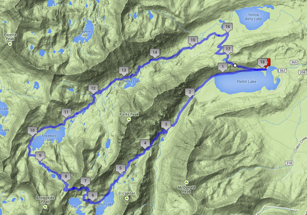
After floating we lounged for a little bit and then stuck to our original plan of getting a couple miles in on the trail. Here is a map of the loop we hiked and camped on. We hiked counter clockwise and the loop total was 18 miles. Pretty manageable over two nights.
Image from google.
Here is a photo of us on the trail on Friday evening.
The first night we camped at Farley Lake. The guidebook said we hiked 4.2 miles but it felt like way more after floating and for the guys who drove through the night. As soon as we got near the lake it started to get really buggy. Mosquitos plus everything else to be exact. This is a long exposure from the campsite.
Photo: Stuart
We got on the trail sort of early (around 8am) to try and beat the heat on Saturday. Our destination for the night was the Twin Lakes which meant having to go up and over the pass. Here is a view of Toxaway Lake and you can see the pass behind it. (the drainage between the two peaks)
Here is a photo of the five of us at the base of the pass. The guidebook said we had about 1000 feet of vertical elevation to gain from here to the top.
Here we are hiking up the pass.
This is us at the top of Snowyside Pass with the Twin Lakes below.
Photo: Stuart
From the top of the pass down to the Twin Lakes wasn’t bad. It maybe took us about 45 minutes. We then setup camp and got to enjoy ourselves. We went swimming, fished, and pulled out some whiskey we brought along once the sun went down. This is me in the lake.
This is Stuart floating on his sleeping pad.
We got to enjoy our whole afternoon on the lake. We scored one of the best spots because we were on a little peninsula that jutted out into the middle of the lower Twin Lake. It honestly felt like we were sleeping in the middle of the lake. This is a photo of the spot taken Sunday morning and you can see our tents popping up in the middle of the point.
We go up early to try and make it to the cars at a reasonable hour so John, Justin and Stuart could drive back to San Francisco so we hit the trail. We had to cross the creek a couple of times and I fell in which meant I had to hike out with wet feet and shoes.
Photo from a bridged creek crossing.
The last mile of the hike was along Petit Lake and we came across this rope swing which I took full advantage of.
That was pretty much it. I would highly recommend visiting Stanley sooner rather than later because the Sawtooths and Salmon River are really worth it. If I could give one piece of advice, bring bug spray and a swimsuit.
Check out what else I have been up to here and remember, get outside and get after it!
Lucifer Lake - Trip Report
I thought it would be cool to write about what I do outside of the office. Since I live in Missoula, MT I thought why not write about what I do in my free time or on the weekends. I like to get outside and enjoy the place I live and now I would like to share what I do with you. My blog posts will be mainly about hiking, biking, rafting and skiing in the winter.
First, a little about me…
My name is Brian and I am an employee at Omnibar. I am 24 years old and really enjoy where I work and the place I live. Describing myself as a weekend warrior might be the best title because I work hard during the week and play hard on the weekends. I like to do everything big whether it is skiing a big couloir or taking on the biggest rapids on the river. I don’t do what I do to impress, I just really like to get after it.
At Omnibar, we are a very small team (2 employees) so it is sometimes hard for me to describe what I do on a daily basis while at work. The big things I do are running our website and managing our warehouse. For those of you who have purchased bars from us you may see that I wrote you a note or sent you an email. So that’s me and now onto the good stuff/this past weekend.
Over the weekend Anthony (the other employee) and I decided to hike into the Mission Mountains and camp for two nights. The Mission Range is north of Missoula and about a 45 minute drive out of town. The north end of the range butts up to Glacier National Park, but we stuck to the south end. This was our first time backpacking in this area so we didn’t really know what to expect. The first thing we had to do was obtain a Tribal Recreation Permit because the area we would be in is part of the Flathead Indian Reservation. Again, new for the two of us but now we have the permits for the remainder of the year so we will sure to be back!
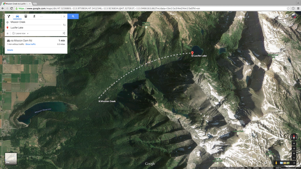
Below is an image of the area we were hiking in. We started just above Mission Reservoir at about 6:45pm on Friday and our destination was Lucifer Lake and then Picture Lake above that.

the dotted line is not the trail.
This is Anthony at the trailhead and we would be following Mission Creek, which is to his left. (elevation 3504’)
This is a photo of where we are heading. At the tip of my finger is Elizabeth Falls and above that is Lucifer Lake.
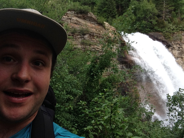
After about 1.5 hours of hiking we came to Mission Falls. That’s me taking a waterfall selfie. (elevation 4941’)
View from the top of the waterfall.
From the top of Mission Falls the trail turns to the left and starts to get thick and steep. We could tell most people hike to the falls as just a day hike because the trail from here on was less traveled. Here is Anthony starting the climb.
We did some more climbing
We did some trail finding
(are we in narnia?)
It started to get dark and we had been on the trail for about 3.5 hours and we didn’t quite know where the lake was. The trail was a little tough to follow and that combined with the little light we had left led us to stop for the night and setup camp. We didn’t make it to our destination but we were happy to take off our packs and eat some food. Here is a photo of our campsite from night one. Taken Saturday Morning. (elevation 6400’)
Night one was a little interesting in the fact that I setup our tent on a level spot except for a large hump in the middle which made for some uncomfortable sleeping. During the night we could hear an animal circling our tent and then chewing on what I now know to be my flip-flops. The straps have some pretty distinguishable bite parks. I did manage to turn on my flashlight while the animal was chewing and got a look. I think it was some type of pack rat. It had a long nose and long tail with a larger and plump body. Not cool.
After not sleeping well we were able to get up and make some instant oatmeal and get going for the day. We hiked for about 10 minutes and came to Lucifer Lake. (yes, we were that close)
Beautiful is an understatement. (elevation 6270’)
Since our goal was to get to Picture Lake for night two we set out on the trail again.
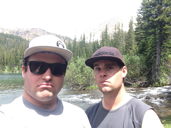
From the south end of Lucifer Lake to the north end it took us about 2.5 hours. We got lost. Found the trail. Lost the trail again and then had to follow the creek on the north end of the lake back down to Lucifer. We were beat, scraped up and tired and it was mid afternoon. If we still wanted to make it to Picture Lake we would have to cross the stream and do our best to find a trail, again. We made the decision to turn around and go back and camp on the south end of the lake but here is the two of us doing our best to look sad about turning back while we were still in such a beautiful spot.
So, we worked our way back around Lucifer Lake and setup camp. Since we still had the afternoon ahead it was time to test the cold alpine water. This is me looking happy but I can tell you, I. Was. Freezing.
The rest of the night we cooked, played some cards and watched the sun set on the surrounding peaks.
Again, on night two some type of animal came and kept us up most of the night. This time it chewed trough a strap on my backpack so I had to use a rope to secure the tent for our hike out.
The hike out was as beautiful as anything. Here is Anthony crossing through a meadow and it just so happened that a black bear was in the same spot.
I think we scared the bear more than it scared us
Overall it was an awesome weekend! The hiking was a little rugged and thick but we managed. Today, Monday, my legs are still burning but it was totally worth it. We don’t know the total mileage but our best guess is about 6 miles to Lucifer Lake with vertical gain of about 2900 feet.
That’s all for now and I will post next week after I meet up with my brother and friends in the Sawtooth Mountains near Stanley, Idaho this coming weekend.
Explore these sites
- Non Gamstop Casinos
- Casino Sites UK
- Best Non Gamstop Casinos Uk
- Nuovi Casino Online
- UK Online Casinos Not On Gamstop
- Casino Non Aams
- Casino Sites Not On Gamstop
- Meilleur Casino En Ligne
- Slots Not On Gamstop
- Non Gamstop Casinos UK
- Casinos Not On Gamstop
- Non Gamstop Casinos UK
- Non Gamstop Casino Sites UK
- Casino Non Aams
- Non Gamstop Casinos UK
- Casinos Not Signed Up To Gamstop
- Casino Sites In UK
- Meilleur Casino En Ligne Retrait Immédiat
- Meilleur Casino En Ligne
- Non Gamstop Casino Sites UK
- Casino Not On Gamstop
- Casino Sites UK Not On Gamstop
- Non Gamstop Casino UK
- UK Online Casinos Not On Gamstop
- Lista Casino Online Non Aams
- Migliori Casino Online Italia
- Casino Online
- Casino En Ligne
- App Scommesse
- Avis Sur Sweet Bonanza
- 코인카지노
- плинко играть
- Casino En Ligne
- Bonus Casino Senza Invio Documenti
- Siti Non Aams Legali In Italia
- Casino En Ligne 2026
- Casino En Ligne Argent Réel
- Migliori Casino Non Aams
- 슬롯머신


